Create your first print layout
Compose a print-ready sheet from a web map: a map frame at a true scale, a legend, a scale bar, a north arrow and your own text — exported as PDF, PNG or JPEG at print resolution.
Layouts need the Editor role or higher and a saved web map to point at — see Create your first map.
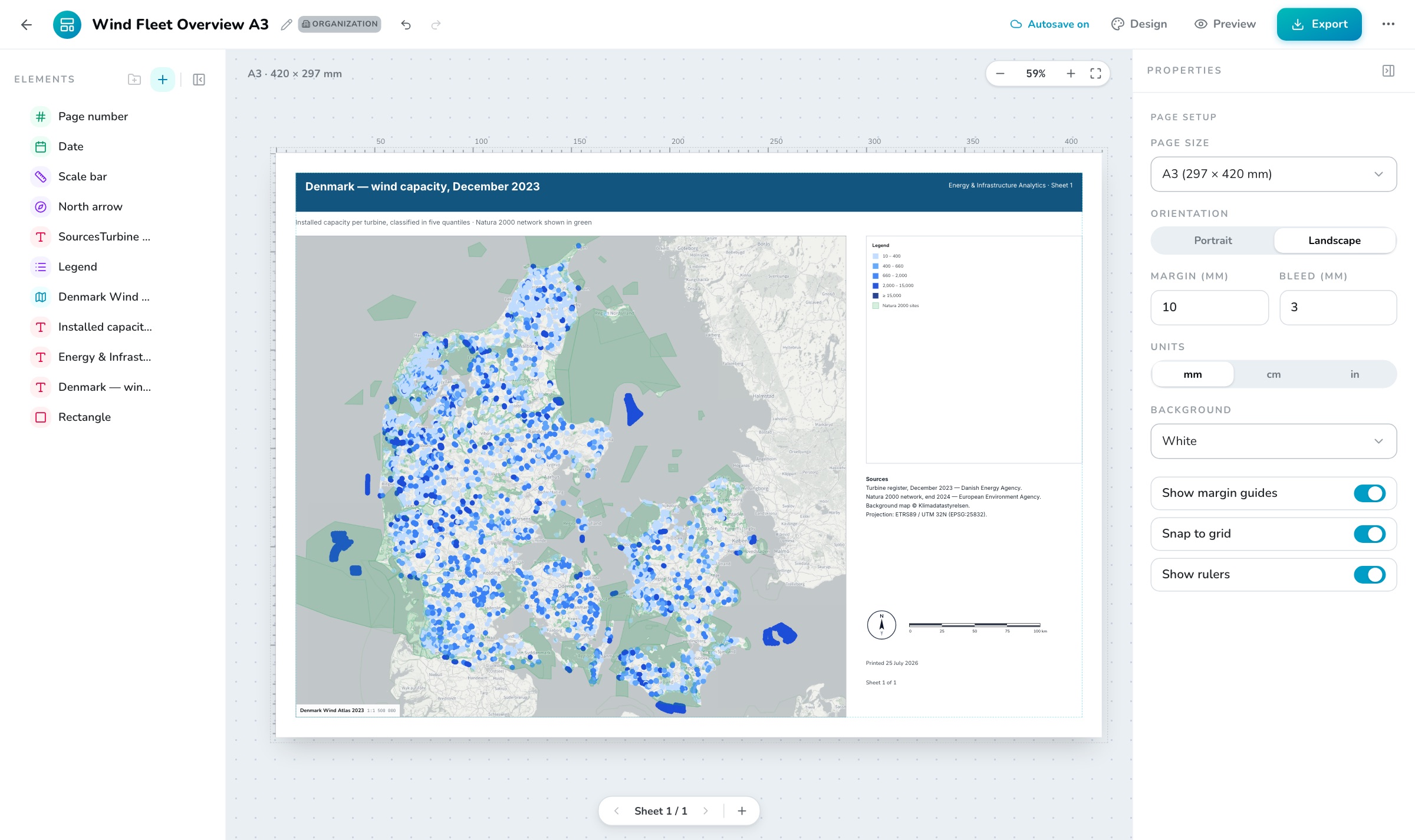
Create the layout
Open Apps → Layouts and press New layout. Start from Blank layout or the built-in A3 map sheet — a landscape sheet with a large frame, legend, scale bar, north arrow and date already placed.
Set up the page
With nothing selected the right panel shows Page setup: Page size (A5 to A1, Letter, Tabloid), Orientation, Margin and Bleed, the display Units, a white or transparent Background, and the Show margin guides, Snap to grid and Show rulers switches.
Place a map frame
Press + in the Elements panel and choose Map frame. In its properties pick the Linked map, then a Scale — a real 1:N ratio, not a zoom level. Drag the frame’s edges to size it; the ground width it prints is the frame width times the scale.
Aim the frame
Press Adjust view on canvas (or double-click the frame) to pan and zoom inside it, then Done adjusting — the centre and scale are written back. Set Extent to Follow view instead if you would rather the frame track whatever the map itself is saved at.
Add the map furniture
Add a Legend, a Scale bar and a North arrow. Each one binds to a map frame on the same sheet — leave the link empty and it uses the first frame. Legend rows are read live from the frame’s visible layers, so restyling the map restyles the legend.
Annotate
Add Text for the title and sources, a Shape for a colour band behind it, Logo / image for a mark (PNG, JPG, WebP or SVG up to 2 MB), and the Date and Page number fields, which fill themselves in.
Arrange precisely
Everything is positioned in millimetres. Elements snap to page edges, margins, the page centre and each other; arrow keys nudge by 1 mm,
Shiftby 5 mm. Reorder in the Elements list — the last element is on top — and lock anything you do not want to move again.Export
Press Export. Choose PNG, JPEG or PDF, a resolution of 96, 150 or 300 dpi, and a filename. Multi-sheet layouts export as numbered image files or one multi-page PDF. Rendering happens in your browser at print resolution — the progress line names each map frame as it goes.
Sheets#
One layout can hold several sheets — use the pager under the canvas to add, switch and delete them. Each sheet has its own elements, and legends, scale bars and north arrows only bind to frames on their own sheet. Page setup is shared by every sheet in the layout.
Where to go next#
- The full element reference — every element and its properties, plus legend styling — is in Print Layouts.
- Save a finished sheet as a template from the ⋯ menu, and it appears for everyone in the org next time they press New layout.
- Need a plain image of a map instead of a composed sheet? Use the map viewer’s own image export — see Exports.
Very large sheets at 300 dpi can exceed the browser’s canvas limit. If an export refuses, drop to 150 dpi or a smaller page size.